Read an IGN map - title

How to read an ign hiking map?

Hiking begins even before walking, as we find out the route on the map. A detailed reading of it will provide all the information on what walkers can expect, hence it is a useful and important tool.

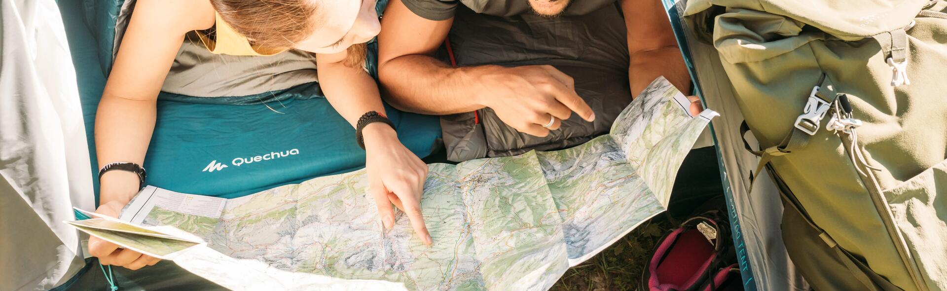
Why learn to read a map?

A map shows the terrain only on a horizontal plane, seen from the sky, minimised and schematised . It takes a little training to establish the relationship between the map and terrain. You can’t read it too quickly. Whether it's to prepare for a hike or to get a sense of direction, your map will always be there to help you, and unlike GPS and mobile phones, it won’t fail. Think of bringing a compass so you never miss the north direction.

Reading an IGN map

Choose the right scale

For hiking, the ideal scale is 1/25 000; that is, 1 cm is equivalent to 250 m, or 4 cm for 1 km. It allows you to see every detail (streams, forests, trails ...) and to obtain a precise sense of location. These scales correspond to IGN Blue Series Maps and TOP25 maps. For those who hike in the rain, there are TOP25R maps ("R" for "Resistant"), waterproof, tear proof and printed double-sided to save space on your bag.

Understanding the colour codes

How to read an IGN hiking map?

Green

Indicates wooded areas

White

Indicates meadows and cultivated areas

Orange

Generally indicates contours

Blue

Indicates hydrography elements (lakes, rivers ...)

Black

It is widely used and refers to everything that comes from human intervention; it also indicates rocks and scree

Good to know

You will see areas that are more or less darkened. Shaded areas on slopes or hillsides give the impression of a relief. By convention, theoretical light mapping is determined as if the sun illuminated the ground from the North West (with an average angle of 45°). This fact is not an element of orientation, it is simply a tool to facilitate the perception of a relief when reading the map.

Use the four information layers for a sense of direction

Reading an IGN map
Reading an IGN map

Identify remarkable points

Details often make it possible to determine one's location in a very precise way.~Cartographers are careful to include all the remarkable elements that are in the areas (a spring, a chapel, a cross, a footbridge, a ruin, an isolated tree, etc.) whether they be natural or man-made.~By referring to the map's legends, it will be easy to identify the element in question.

Orienting one's map without instruments

By convention, the north is located at the top of the map.~If you rotate the map in a flat position facing you such that the elements of the terrain are aligned with the map's symbols, you will be able to get the correct orientation of the map.

To learn more about the art of mapping, do not hesitate to watch the videos developed by the ign.

How to read an IGN hiking map? Orientation, scale, we tell you all!

Cloé

Hiking lover at Quechua

Hiking with children - teaser

Hiking with young children

Take the time to look carefully at the map and its contours or carry out a reconnaissance of the route.Take the opportunity to check out the orientation and try to choose shady trails in summer - the whole family can keep cool and it will be more pleasant when you take a break.

Find out about trail grading so you can find a hike to suit your level - title

Find out about trail grading so you find a hike to suit your level

Find out about trail grading so you can find a hike to suit your level! The French Hiking Federation has developed a trail grading system based on 3 different criteria: effort required, technical difficult and risk involved.

Nature Explore

Nature Explore

Find all our Quechua hiking & camping tips about nature exploration. Learn about nature observation, fauna & flora for your next outdoor exploration!

Top Tips for How to Wash Your Down Jacket

Top Tips for How to Wash Your Down Jacket

Washing your down jacket won’t just get rid of marks and odours, it’ll also rejuvenate the insulating properties of the filling – if done right!

7 tips to conquer acrophobia when hiking

7 tips to overcome the fear of heights when hiking

If you are familiar with that feeling then you may be prone to acrophobia: the fear of heights. Here are 7 tips to control this fear and make your hiking more enjoyable.To note: this advice should not be used as a substitute for the recommendations of a phobia specialist.

How to repair the poles of a tent?

How to repair the poles of a tent?

Has one of your tent poles been damaged by the weather or in transportation? No need to panic, learn to repair it using this video that will give you a step-by-step guide.

Learn about hiking - title

Learn about hiking

It's said that beautiful landscapes have amazing restorative powers and hiking has proven benefits for walkers; so what are we waiting for.